MONTANA
 horse ranch |  Mocassin Mtn. |
 Salish Women |  Salish Family |
 Advertisment |
 F. Strouf's wagons |
 F. Strouf's steam engine |
 Frantisek Strouf |
 Bartas brothers' wedding, 1912 |
 Vondrachek's family |
"I walked on shore and ascended this river about a mile and a half in order to examine it. the water of this River is clearer much than any we have met with great abundance of the Argalia or Bighorned animals in the high country through which this river passes. Cap. C. who assended this R. much higher than I did has thought proper to call it Judieths River. (For Julia - Judy Hancock of Virginia, whom Clark later married.) on the Missouri just above the entrance of the Judith River I counted the remains of the fires of 126 Indian Lodges which appeared to be of very recent date perhaps 12 05 15 days." (from The Journals of Lewis and Clark).
The original inhabitants of Judith basin were in the North Assiniboine and Blackfeet. To the South were Salish, Crows and the Sioux.
Like many other farming communities of the West, the small towns of Judith Basin in Central Montana grew along the new tracks of railroads. This part of Montana promised an agricultural paradise - the land was considered fertile for growing a variety of cereal and wheat. Most of the new farmers coming to Montana were from Wisconsin, Illinois, Iowa, Nebraska and Oklahoma.
The majority of the Bohemians were no exception. They were lured to the area by the prospects of large tracks of land. By the time the Bohemians started arriving in America in significant numbers, the more fertile farm land in the East and partially in the Midwest has been already appropriated. They were also pressed on westward by rough environment in the Midwest, such a locust or grasshoppers, drought, or floods. And sometimes there was just not enough land to pass on to the next generation.
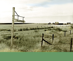
Before the homesteaders, Judith Basin was mostly occupied by sheep, cattle and horse ranchers. The cattle were herded to Fort Benton for sale, then shipped via Missouri River to the East. After the Great Northern Railroad completed their track across Montana in 1891, the nearest center for the farmers was Great Falls. When railroad tracks came to Stanford in 1910 it became a trading center for the ranchers as well as the central location for the pioneers of dry land farming. They were hauling their wheat to the grain elevators either with wagons and teams or with steam engines.
Aggressive promotion of dry land farming by the railroad companies in Midwestern states and in Europe brought many homesteaders to the arid West. Between the years of 1909 and 1920, 157,000 first entries were filled in Montana. But it was not only the railroad companies propaganda, which appealed to the homesteaders. In 1912 the US Department of Agriculture bulletin published a report of crop production from Judith Basin Experimental Station: 70 bushels of oats per acre, 33 bushels of wheat and 45 bushels of barley. These were attractive production numbers for land without significant source of water. With the Enlarged Homestead Act of 1909 Congress expanded the acreage a farmer could file claim on to 320 acres on lands classified as "dry farming" lands. To encourage the homesteaders even further, in 1912 the "prove up" period was also reduced from 5 years to 3 years. Congress also added a "provision given certain privileges to homesteaders who went insane. They were excused from residence and cultivation provisions of the law, and their homesteads could be proved up by the guardians." (from Daniel N. Vichorek's Montana's Homestead Era.)
The Bohemians who came to Central Montana settled around the following communities: Arrow Creek,Coffee Creek, Denton, Danvers, and Kolin. This map highlights the homesteads with Czech names.
The area covers approximately eight hundred square miles and stretches for almost fifty miles along highway 81 west of Lewistown.
Explore some of the narratives: Frank Strouf
Frank Barta
Charles Vondrachek's family
The original inhabitants of Judith basin were in the North Assiniboine and Blackfeet. To the South were Salish, Crows and the Sioux.
Like many other farming communities of the West, the small towns of Judith Basin in Central Montana grew along the new tracks of railroads. This part of Montana promised an agricultural paradise - the land was considered fertile for growing a variety of cereal and wheat. Most of the new farmers coming to Montana were from Wisconsin, Illinois, Iowa, Nebraska and Oklahoma.
The majority of the Bohemians were no exception. They were lured to the area by the prospects of large tracks of land. By the time the Bohemians started arriving in America in significant numbers, the more fertile farm land in the East and partially in the Midwest has been already appropriated. They were also pressed on westward by rough environment in the Midwest, such a locust or grasshoppers, drought, or floods. And sometimes there was just not enough land to pass on to the next generation.
Before the homesteaders, Judith Basin was mostly occupied by sheep, cattle and horse ranchers. The cattle were herded to Fort Benton for sale, then shipped via Missouri River to the East. After the Great Northern Railroad completed their track across Montana in 1891, the nearest center for the farmers was Great Falls. When railroad tracks came to Stanford in 1910 it became a trading center for the ranchers as well as the central location for the pioneers of dry land farming. They were hauling their wheat to the grain elevators either with wagons and teams or with steam engines.
Aggressive promotion of dry land farming by the railroad companies in Midwestern states and in Europe brought many homesteaders to the arid West. Between the years of 1909 and 1920, 157,000 first entries were filled in Montana. But it was not only the railroad companies propaganda, which appealed to the homesteaders. In 1912 the US Department of Agriculture bulletin published a report of crop production from Judith Basin Experimental Station: 70 bushels of oats per acre, 33 bushels of wheat and 45 bushels of barley. These were attractive production numbers for land without significant source of water. With the Enlarged Homestead Act of 1909 Congress expanded the acreage a farmer could file claim on to 320 acres on lands classified as "dry farming" lands. To encourage the homesteaders even further, in 1912 the "prove up" period was also reduced from 5 years to 3 years. Congress also added a "provision given certain privileges to homesteaders who went insane. They were excused from residence and cultivation provisions of the law, and their homesteads could be proved up by the guardians." (from Daniel N. Vichorek's Montana's Homestead Era.)
The Bohemians who came to Central Montana settled around the following communities: Arrow Creek,Coffee Creek, Denton, Danvers, and Kolin. This map highlights the homesteads with Czech names.
The area covers approximately eight hundred square miles and stretches for almost fifty miles along highway 81 west of Lewistown.
Explore some of the narratives: Frank Strouf
Frank Barta
Charles Vondrachek's family
view quicktime of today's Judith Basin
and Coffee Creek
more images of today's central Montana